The Lower Moore River Working Group...
|
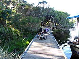
... is a non political working group that purely focuses on the Lower Moore River and its environs. The much loved area, just one hour's drive North of Perth, is becoming an ever-increasing recreational playground for Perth and the impacts are being felt in the environment. We actively manage Weed Infestation, Revegetation, Walking Trails and Boardwalks /Fishing Platforms and erosion due to boat traffic and livestock. We work with local landholders also to revegetate, fence and direct stock from bank degradation. The group is also involved with funding for grants to complete water sampling and various studies of the river system and its health. Our constitution is quite simple;
"Rehabilitation, conservation and maintenance of the Lower Moore River and its riparian zone." |
|
|
We encourage any volunteers or groups that are interested in assisting our projects for planting days, fencing, sandbagging, construction or weed management to register their group through the contact page.
The Moore River is a river in the Wheatbelt of Western Australia. The headwaters of the river near Walebing and flow westerly before joining with the Moore River East near Mogumber then flow in a Westerly direction. The river flows over the Edengerie Cascade through the northern edge of Moore River Nature Reserve then through the escarpment and discharge into the Indian Ocean in Guilderton. The river includes a catchment that extends from just south of Three Springs to Guilderton. The catchment has a total area of 13,540 square kilometers (5,228 sq mi) and is mostly cleared. The catchment area is used for broadacre farming but with increasing diversification in horticulture and tree plantations. The river mouth at Guilderton opens and closes cyclic depending on rainfall. It is naturally fed by springs near Moora. The river was named in 1836 by Private Patrick Heffron who named it after George Fletcher Moore who was the leader of the expedition that Heffron was a part of. The river has nine subcatchment areas and has a number of tributaries and lakes along the length of the river. The salinity levels in the river catchment vary from brackish to saline with the exception of Gingin Brook which remains fresh throughout the year. |
|